| Home | Tours/Lectures | Books | Maps | Posters | Pictures | Contact |
TABLE OF CONTENTS Before You Start Introduction Tour I: From Dene to Green Tour II: Overlook Rock Tour III: Umpire Rock Tour IV: Belvedere Lake Tour V: Woodland and Waterside Glossary |
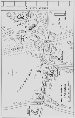
TOUR I: FROM DENE TO GREEN
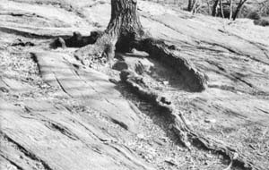
Enter the park from Fifth Avenue just south of 67th Street, walk around the playground to the north and bear sharp right on the narrow path that leads up the hill. When you come abreast of the first tree on your right, an oak with a plaque at its base, notice how the asphalt has bulged and slumped, demonstrating the action of water, frost and gravity in producing a miniature landslide. In line with the next tree, an ailanthus, you will see curved ridges, some broken into crevasses, on the surface of the path. This is a working model of an alpine glacier, accurate even to the flow which is more rapid in the center than at the sides. Here is evidence that under the combined forces of gravity and time, solids such as asphalt and ice can be induced to flow. Opposite lamp post #6704 is an even more extensive asphalt glacier, a small-scale representation of the movement of ice down a steep mountain valley.
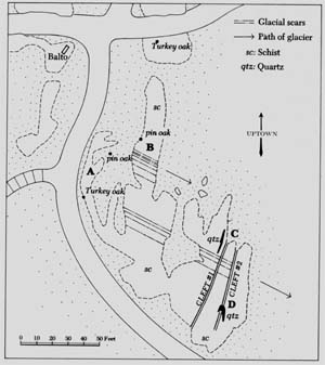
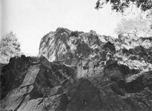
After you go up the steps, walk to your right to the angle where the paved overlook widens. Here you will be able to locate the start of a fracture, marked A on the map. Follow it up the slope, taking time to study the distinct layering characteristic of sedimentary rock layers once horizontal but later upturned, crushed and folded into sinuous lines. Raised knobs and ridges, easily felt through rubber-soled shoes, are hard minerals which have withstood erosion better than the surrounding rock.
|
| Route of Tour I. |
At the highest point of the slope, walk north and stand near the edge of Cleft #1. At your feet, and even more clearly displayed on the far side of the cleft, is a conspicuous band of pegmatite indicated by a serpentine line on the map. Pegmatite is readily identified by the large grains of its mineral components: pink microcline, glassy-gray quartz and flakes of silvery mica.
The pegmatite band runs parallel to the layers of the host rock and follows its contours like the filling in a jelly roll. Apparently the pegmatite, in molten form, was injected into a crevice or weak zone in the hot, still-plastic schist and was folded and metamorphosed with it. Slow cooling within the rock mass promoted growth of the coarse grains that characterize pegmatite.
When you step across the cleft, you span the effects of several hundred thousand years of geologic history. The stupendous pressures that folded the Earth's crust and raised mountain ranges have now subsided. The rocks on which we stand, insulated and weighted by a vast overburden, are gradually giving up their heat. Once pliable as taffy, they are becoming hard and brittle, with the intrusions of pegmatite and the patterns of earlier folding now indelibly recorded in stone.
As the rock cooled, it tended to crack under stress, often in fairly straight lines. If you follow the course of the pegmatite ribbon 4 1/2 feet north from the edge of the cleft, you will find it intersected by a six-inch band of granite. This is a fine-grained igneous rock, dull tan or gray in color, with minute dark flecks that show up under a band lens. The granite, instead of following the folds of schist as the pegmatite does, cuts boldly across its layers. The molten material, held between walls of cooling rock, lost heat rapidly and formed small grains.
Once you have located the band of granite, vou can trace its course in a nearly straight line southwest to a knob at the end of the outcrop near an unnumbered lamp post, and northeast across the entire surface until it disappears under the turf. If you want to distinguish rock types with greater clarity, repeat the tour on a misty day or after a shower. When rocks are wet, their colors and grain textures are greatly enhanced -- as you may recall when you collected brightly colored pebbles at the edge of the surf and found them turned uniformly drab by the time you got them home.
Follow the ribbon of pegmatite to the edge of Cleft #2. The zigzag path of the pegmatite and the strongly waved pattern on the slope to the west testify to the tremendous force that bent and crushed these sedimentary layers. As you look down on the surface at the far side of the cleft, you can see clearly defined bands of different grain textures (B). The formation, a dipping fold, resembles a quartered watermelon with its stem end pointing east. Tbe raised loop is its rind. As we leave the outcrop at the end of this stop, we shall pass the cut end of the melon and see clearly how the inner layers conform to the curve of the rind. The hollowed center of this fold contains large quartz crystals. As these are irresistible to children, the near-white color of newly fractured quartz is often visible.
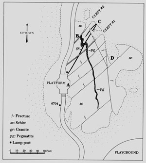 |
| Map of the first stop on Tour I. |
On the far side of Cleft #2, near its eastern tip, you move into the present where decomposition of rock is in active progress. The deformed strata are here upended so that the weak mica layers are fully exposed to penetration by rain. The disintegrating forces of water and frost are further reinforced by chemical action: as the rusty color indicates, the iron content of the rock is being broken down by oxidation. Grass roots have found lodging in the rotting mica bands and will assist in the ultimate decay of this section of rock. This is a small-scale demonstration of the gradual but relentless erosion that wears down mountains and releases mineral grains to form the basis of soil in valleys and lower slopes. Man-made debris -- paper, broken glass and the pull tabs of beverage cans -- contribute their share of bulk as they are reduced to fragments.
 |
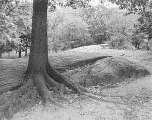
| The north side of the outcrop with the grassy cove on the left. |
Turn south and walk towards the flat slab of rock east of the main outcrop. The band of granite, first seen on top of the outcrop, continues in two stripes down the face of the cliff to the west and crosses the slab you stand on, then merges into a single strand (C) just before it dips under the soil on the east side.
Keep walking south to a grassy cove (D) surrounded on three sides by rocks. On the west side is an interesting steplike formation. The sloping layers of evenly grained rock might be expected to shed rain like slates on a roof. However, upturns in the folding have exposed some pervious layers between the hard rock slabs. Water has seeped into the chinks and, in freezing, has split off the tough upper strata.
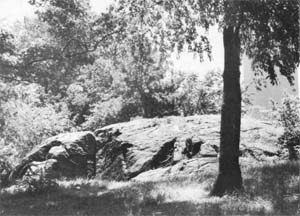
Return to the paved overlook either by scrambling over the outcrop or skirting its north end. To the west is the hollow known as the Dene, where scattered outcrops break the irregularly rolling contour of the meadowland. These apparent islands of rock are really protrusions of the underlying bedrock -- a mountain range in miniature, with bald rocky peaks rising above the veneer of soil in the intervening valleys.
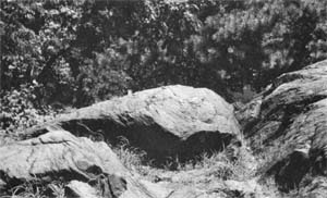 |
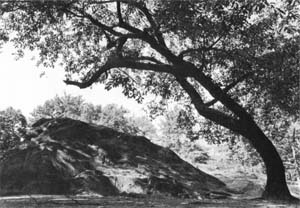
| The "watermelon" (B on the detail map) with Cleft #2 on its right. |
As you start walking north on the paved path, Stop at the second cleft to note the cross section through the dipping fold (B), the "watermelon" seen earlier from above. From this angle, it is plain that the raised loop, or rind, forms a continuous basin to which the inner layers conform.
Continue north and west on the asphalt path until it meets the main footpath, turn sharp left and walk south to the V fork with a four-trunked Osage orange at its tip. This tree is an example of coppice growth: the main trunk died and four suckers grew from its base, leaving a vulnerable hollow in the center. In 1972, the tree was pruned and four cables were installed to secure the divergent trunks. The work was funded by the Arthur Ross Foundation as part of the program of tree restoration carried out by the Friends of Central Park.
Take a moment to study the tree and fix its characteristics in mind. If you are able to recognize the species, it will help you to locate a rather obscure feature at the last stop on this tour. The most obvious aspect of an Osage orange is its glowing orange bark, often split and showing the darker sapwood beneath. In late summer, female trees such as this one bear globular fruit four to five inches in diameter, bright chartreuse in color and convoluted like the surface of a brain.
Pass to the right of the Osage orange and continue walking west. On the way, notice how trees have managed to find a roothold in rock crevices. These trees could not have been deliberately planted but result from seeds blown by the wind or, in the case of oaks, from acorns buried by squirrels or bluejays. Seeds that sprout in rocks are spared beheading by lawnmowers, which may account for the number of rock-based volunteer trees and shrubs in the park as compared with their absence in areas where the grass is shorn.
Some authorities assert that growing roots exert considerable hydraulic pressure and thus help to widen cracks in rocks. Others believe that roots merely hold crevices open so that water can penetrate and split the rock by the action of frost. Since frost heaving can reach pressures as high as fourteen tons per square foot, it seems capable of splitting rocks without the help of roots.
 |
| A rock-rooted Turkey oak across the path north of Balto. |
Fifty feet east of Balto, a Turkey oak is firmly seated in a crevice at the edge of the path on the left. The low limbs of this delightfully compressed tree had been splintered by garbage trucks forcing their way against them. Treatment of this oak and extensive care of the magnificent multitrunked sweet gum south of Balto -- pruning, feeding, cabling and cavity treatment -- were provided by the Arthur Ross Foundation.
Another rock-rooted Turkey oak stands on a rise across the path to the north of Balto. This and the tree oaks that grow on the main outcrop are stunted by adversity yet gain the compactness of form that distinquishes such natural bonsai. Because of their small size, these four trees seemed especially appropriate for ladies and accordingly were chosen to receive treatment through proceeds of permanent funds established in memory of Dorothy Lieberman, botany teacher and lover of Central Park, and of Marianne Moore, poet and champion of trees. The two-trunked Osage orange on the slope to the west of Balto was also pruned and cabled by the Friends of Central Park.
To turn from trees to the rocks that support them, walk south on the path to Balto's right as far as the steps on the southwest side. Directly across the path from the steps, to the left of some seedling maples and about eight feet up the slope, you will see some threadlike raised lines (A) that cut nearly at right angles across the grain of the rock. These are veins of quartz thought to have originated when scalding, silica-rich fluids were forced by subterranean pressure into hairline fissures in the rock. As the fluids cooled, minerals were deposited on the walls of the fissures, eventually sealing them and welding together the fragmented rock.
If you walk north a few paces until you reach a more gradual incline, you will find it easy to climb up onto the outcrop. As you turn south, look to a ridge a little to the southeast where a pin oak spreads its roots octopus fashion over the side of the crevice it grows in. Behind the tree and also twenty feet to its right, the ridge is cut by broad rounded grooves (B) flanked with lines of parallel indentations. The grooves were made when a succession of enormous boulders, perhaps similar to the one we shall see at the fourth stop on this tour, were trapped in the sole of a glacier and dragged across the bedrock as the ice advanced. Since a moving ice sheet 1,000 feet thick would exert a pressure of 57,000 pounds per square foot, it is understandable that a hard boulder, impelled by such crushing force, could gouge a furrow in solid rock. This groove, like other glacial scars in the area, indicates the glacier's path as it moved across the site of Central Park.
 |
| Map of the Balto outcrop. |
As you walk south on the outcrop towards its highest point, you will see many hairline ridges of quartz cross-hatching the mass in a diamond pattern. The quartz fills multiple fissures that must once have divided the rock into a three-dimensional jigsaw puzzle. As noted earlier, the cracking of the rock may have occurred when it was subjected to stress after it bad lost plasticity or -- as erosion wore away the mountains above it -- when release of pressure allowed the rock to expand and spread out like a head of cauliflower. Whatever the cause or combination of causes, it is evident that the seemingly solid outcrop we stand on is in fact a heap of fragments cemented together by a tough network of quartz. In addition, folded and upended strata and intrusions of pegmatite record the complex, sometimes violent history of these rocks from the time they were deposited as sediment on the floor of a shallow sea to the present day.
 |
| Glacial grooves cut across the outcrop beyond the spreading roots of a pin oak. |
A broad glacial groove is evident about halfway up the slope that leads to the highest point of the outcrop. Its smooth surface and the direction of its path as it angles across the grain of the rock readily distinguish such glacial scars from clefts formed by the decay of weak layers.
As you approach the first cleft, you will see some conspicuous bands of quartz. One of these (C) is especially well displayed on the upright face of a small rise to the northeast. The origin of these bands is enigmatic. Veins of alien minerals that cut across the grain of the host rock are obviously igneous or aqueous intrusions. In this case, however, the quartz bands conform with the layering of the schist and share the same pattern of folding and tilting. It is impossible to determine whether the quartz was deposited as a sedimentary layer of quartz sand on the sea floor or whether it was injected into the schist along an existing fissure.
The cleft is formed, as we saw at the first stop, by decay of an upended mica-rich layer. Where differentiated strata remain more or less horizontal, hard layers protect the more porous ones by shedding water like the plastic covers of a notebook. Here, however, the book stands on its spine with the gaps between the pages fully exposed to the ravages of rain and frost. The inner walls of the cleft show areas of rotting, flaking rock, demonstrating the continuous action of erosion in reducing mountains to grains of sand.
As you walk south to the second cleft, you will see some exceptionally broad bands of quartz (D). These conform to the layers of schist yet seem to have spread them. As the mass of quartz crystals grew, it may have elbowed space for itself by pushing apart the schist layers. If, later, the rock mass had been subjected to compression, the dense quartz crystals would remain intact while the more yielding schist would be squeezed even more tightly around them.
When you stand on the highest point of the outcrop and look down on the broken rock to the southwest, you can see clearly how the sedimentary layers deposited on the sea floor have been tilted nearly at right angles to their original horizontal position. This was caused by horizontal compression which forced the strata into a huge fold, of which only the side remains.
 |
| The east side of the outcrop near Balto. |
At the sides of the cleft, the exposed edges of vertical strata show flaking where water has penetrated. The rate of erosion, while perceptible in weak zones, is not cause for general alarm. Glacial scars made between 15,000 and 75,000 years ago are still plainly visible, so the rocks that bear them may be expected to last for a few more millennia.
For the shortest way down, return to the first cleft, walk down the slope to the east and circle around to the south end of the outcrop. This route can be unpleasantly muddy when the ground is rain-soaked or thawing. In this case, you may prefer to retrace your steps across the rocks towards Balto, then follow the paved path to the south.
At the southwest corner of the outcrop, natural erosion and frost wedging have been augmented by blasting to clear away a portion of the outcrop which perhaps originally continued across the path and into the hillside on the west. As you stand below the cliff, you can see how the softer layers of schist have weathered away, leaving the more durable strata standing as isolated slabs.
 |
| The cliff at the southeast end of the outcrop. |
The process of wearing down rock masses is uniform whether on a vast scale or a tiny one. If you can screen out buildings and trees and reduce yourself to sparrow size, your imagination can transform this rock face into a towering cliff in the Dolomites.
Return to Balto, turn left in front of the statue and pass under Willowdell Arch; turn left again and walk south to the statue of Columbus at the terminus of the Mall. Cross the drive at the traffic light. On the far side, turn sharp right on the path, then left at the first fork and continue across the bridge over the concealed transverse road.
 |
| On the Kinderberg, the path of the glacier from northwest to southeast is indicated by the gradual slope on the right and a steeper grade to the left of the steps. |
As you approach a crosswalk, you will see the Kinderberg, the Children's Mountain, ahead and slightly to your right. The outcrop bears many glacial scars, notably several broad channels that lend a wavelike surface to the children's sliding surface. These troughs show the path of a glacier but not its direction of travel.
If you stand back a little to observe the shape of the outcrop, you will learn to recognize a distinctive mark of glacial activity by which the course of an ice sheet can be determined.
Typically, a glacier tends to slide up the near side of an outcrop, polishing the surface when its cargo consists largely of fine grit, or scoring grooves if it carries large boulders. As it passes beyond the highest point of the outcrop, the ice, in falling, rips off blocks of bedrock and carries them off embedded in its sole. The action is not unlike that of a waterfall and produces a similar steep, rugged, sometimes undercut cliff. The result is a gradual slope on the side from which the glacier approached and a fairly steep cliff on the far side. The modeling of this outcrop, which is consistent with others in the park, indicates that the glacier moved from the northwest to the southeast as it passed over the area. If you are lost in a wilderness over which a glacier moved in a known direction, you might use these glacial arrows to orient yourself. The method is at least as accurate as plotting your course by the growth of moss on tree trunks.
Where the north edge of the outcrop was blasted to make way for the path, the jagged rock surfaces sparkle with mica. The flat crystals are especially brilliant when picked out by the slanting rays of late afternoon sun.
As you walk slowly to the west, you will recognize many familiar features on the outcrop: trees and shrubs rooting in a crevice, folded layering running up the slope, and glacial grooves cutting across the grain of the rock. The relatively smooth surface of the outcrop results from the sandpaper action of grit embedded in ice but the high gloss of the sliding surface is due to seats of pants.
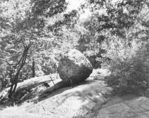 |
| The balanced boulder west of the carousel. |
Go under Playmates Arch and continue walking west, keeping the carousel on your right. On the far side of the carousel is a large boulder resting on a pedestal of bedrock. This is loosely called an erratic-literally, a wanderer. To a purist, a true erratic is of alien rock, proof that it was indeed transported from a distance. This boulder, however, is of pegmatite -- 'country rock' in the geologists' engaging term. The surface of the boulder has been roughened by some 15,000 years of weathering but its generally rounded contour, with some flat sides but no sharp edges, suggests that it was dragged and tumbled in a moving glacier. Because it is a type of rock prevailing in the area, there is no way of telling where it originated or how far it traveled. It was probably found in the vicinity, perhaps when the Playground to the south was being cleared.
The boulder's placement on top of an outcrop is more apt to be the work of man than of nature. Central Park has many balanced rocks -- far too many, in fact, to be natural phenomena. Furthermore, it is unlikely that a glacier would be so selective as to deposit all its cargo on rocks and none on the earth.
Frederick Law Olmsted, co-designer of Central Park, delighted in surprises. Many features of the park's scenery are intended to inspire a sense of wonder, an appreciation of what Olmsted called "the childish playfulness of Nature." If the boulder excited astonished speculation about how it got up there, it was well worth the trouble of raising.
The boulder rides the outcrop at an uncomfortable angle but it must be more stable than it appears or it would have been unseated long ago. However, it looks so precarious that nervous visitors must have insisted on having it secured. The spikes are no more than visual comfort as the boulder would hop them with ease if it ever got moving. It is pleasing to note that the park keepers dutifully placed spikes in back of the boulder to keep it from rolling uphill.
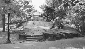
Return to the carousel, circle to the north just beyond it and walk up the hill. Turn left where lamp post #6660 stands in a fork of the path. As you proceed, you will see on the right the first of two heaps of stone placed on the south margin of the Sheep Meadow, or Green as it was formerly called. These piled rocks are sometimes referred to as erratics but their sharp points and edges -- and, in some cases, drill holes -- indicate that they were recently quarried, perhaps when the transverse road immediately to the south was blasted out of bedrock.
So much of Central Park's plant material has vanished -- by means of air pollution, neglect, overuse or deliberate stripping by untaught laborers -- that in many places bare rock predominates over greenery. This is a tragic reversal of Olmsted's intention. As his writings repeatedly state, he detested naked rock and wrote innumerable instructions on how to cover it with "the richest luxuriance of foliage." One of his methods for disguising flat outcrops, which would otherwise look at a distance like patches of dead grass, was to heap rocks on them as a support for substantial vines such as wisteria, trumpet vine and the sweet-scented clematis known as Traveler's Joy.
In addition, according to Olmsted's specific instructions to gardeners, "Rock edges and clefts at various points. . . . [including] north of the Green ... are to be dressed with peat and wood earth and planted with ferns, mosses and Alpine plants." It was one of Olmsted's bitterest complaints about the ravages of the Tweed Ring's henchmen that "the leaf-mould, with which the crevices of the ledge had been carefully filled for the sustenance of plants, was swept out with house-brooms. . . ." If you can picture the heaped rocks wreathed in vines and the flat outcrop softened with small plants, you will see how the assembly would blend into the thick screen of trees and shrubs that once concealed traffic on the transverse road.
The flat outcrop to the west of the piled rocks can be viewed as relief model of an ancient worn-down mountain range, perhaps the Appalachians as seen from partway to the Moon. Through differential erosion, in full as in reduced scale, resistant zones form the ridges of mountain chains, while valleys are formed by erosion of softer strata. The asphaltic intrusion, of recent origin, ensures that Olmsted's desire to grow rock plants in crevices will be forever frustrated.
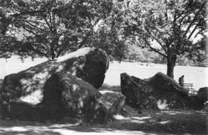 |
| The second pile of rocks on the south margin of the Sheep Meadow. |
As you walk towards the second heap of rocks on the right, notice the scattering of boulders ahead on the left. This was not a dumping ground for waste material but a planned adjunct to the massive screen planting that bordered the sunken transverse road. A solid row of spruces (long dead from contaminated air) lined the top of the retaining wall, faced down on the park side by understory trees and shrubs interspersed with rocks, the whole tied together by a complex of wildflowers and vines.
In his travels abroad, Olmsted became well acquainted with the open English parklands popular in the Eighteenth Century, landscapes designed primarily as pasture for domestic cattle and deer. He knew that endless expanses of lawn dotted with trees can be unbearably monotonous. In order to give city-bound New Yorkers a varied sample of country experiences, Olmsted introduced "landscape passages strongly contrasting with those of the pastoral and high wood districts in complexity of grouping, and the frequent density, obscurity, and wild intricacy of low growing foliage, especially on broken and rock-strewn surfaces." The italics are Olmsted's: they indicate the vital importance he attached to seemingly wild plantings that carried out his prime intention of "making the visitor feel as if he had got far from the town." When the purpose of the now-desolate rock piles is understood, they become part of a carefully composed landscape picture capable of being restored by competent administrators.
As you approach the second pile of rocks, your fancy may see in them a head-on confrontation of monsters: the one on the left, with bulging forehead, might be a whale or conger eel, while the one facing it resembles the head of a giant wolf or Snoopy with his upturned nose. The latter, an especially handsome mass of pegmatite, displays showy leaves of silvery mica as well as large grains of bright salmon-pink microcline. Pegmatite grains vary in size from less than an inch to many feet in width. In addition to slow cooling at depth, it is believed that the presence of quantities of water in the molten rock may contribute to the formation of large grains. A drill hole low on the northeast face and another in front of Snoopy's left eye prove that the rock was quarried by engineers and not deposited by a glacier.
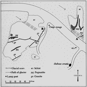 |
| Map of the three last stops on Tour I. |
Continuing west, just before you reach lamp post #6513, you will find an obscure path to the left. As this leads to a hideaway for tramps, it may be wise not to enter it if you are alone. On the other hand, the thicket contains the only undisputed erratic to be found on this tour. If curiosity triumphs over caution, look for the first rock on the right before the path makes a turn. This is a diabase boulder of medium size, dark gray in color and minutely speckled. It was transported in glacial ice from the Palisades, probably from the vicinity of Fort Lee.
This diabase originated some 200,000,000 years ago when deep fractures in the Earth's crust penetrated zones of molten rock far below the present Hackensack Meadows. Some of the magma followed the fractures and erupted on the surface, cooling quickly to, form fine-grained basalt. Other masses of molten material branched out from the fractures between the sedimentary layers of the overlying sandstone, ultimately reaching an estimated thickness of 900 to 1,000 feet. This intensely hot layer, insulated by the rock that enclosed it, cooled fairly slowly into medium-grained diabase.
By the time the Wisconsin ice sheet moved down from the northwest, perhaps as recently as 75,000 years ago, the upper crust of sandstone and probably much of the diabase filling had eroded, leaving the remaining diabase exposed to the quarrying action of the glacier.
Almost directly across the path from the entrance to the diabase thicket is a third outcrop, higher than the previous two and heavily marked with glacial scars. Starting near the center of the rock where it emerges from the pavement, a narrow wormlike ribbon of pegmatite (A) slants upwards towards the east. This pegmatite was injected into a mica-rich layer of schist. If you examine it closely, you will see that in some places the mica grains are compressed and bent out of alignment by the tightening of the pegmatite folds at their inner angle. The wavering path of the pegmatite indicates that it was injected into the schist while the host rock was still undergoing deformation.
About ten feet higher on the slope, several bands of coarse-grained pegmatite cut across the layering of the outcrop. The upper portions of the bands have blurred outlines as if they may have melted some of the schist and mingled with it.
The last stop includes all of the geologic features encountered on the tour and is inevitably complicated but possible to unravel if you take it slowly. As a start, walk west to the Osage orange that stands on the left side of the path. As you look southwest from this point, you can see that the outcrop, though fairly flat, demonstrates the pattern of glacial modeling by showing a smooth, gradual slope on the approach side. Later on the tour, when you stand near the far edge, you will see a more abrupt dropoff.
 |
| The granite dike (B on the detail map) starts at the right of the Osage orange and is visible in the picture just to the right of the finger-shaped leaf shadow. |
As you stand facing the Osage orange, trace an imaginary line from the west side of its trunk towards the south. This line follows the course of a band of granite three to four inches in width.
Up to now, technical terms have been used as sparingly as possible. It is difficult enough for a beginner to master a flood of new information without learning a new language at the same time. However, by now you should be experienced enough to add two precise and useful terms to your vocabulary: 'dike' and 'sill.' A dike is an igneous intrusion that cuts across the foliation of the host rock. A sill is an intrusion that slips between the layers and runs parallel to them. The strip of granite at your feet crosses the grain of the schist and is therefore a dike.
The granite dike cuts across the schist in a nearly straight line, broken by two minor folds where the granite doubles back on itself.
As you stand over the granite, stoop down for a closer look. The dike is set off on both sides by a narrow band of pegmatite. As we have learned earlier, quick cooling produces fine grains. It would be expected, therefore, that the molten granite would crystallize most rapidly where it touched the walls of cooled schist. However, remember that schist originated as a marine sediment. Water in the schist, vaporized by the intense heat of the intrusion, may have diffused into the granite's border, thus causing the formation of large grains.
Walk slowly south along the granite dike. About three-quarters of the way across the outcrop, the band meets another granite dike (C) to form a T. The short arm of the T runs off to the east. The west branch of the T splits in two: one section curves southwest, cutting off the corner of the outcrop, while the second and wider branch heads west. Its course shows some wavering but not the drastic contortion of the host rock. The granite's border of pegmatite is especially well displayed about three feet north of the stub of an iron pipe set in cement.
The granite dike disappears under grass on the west side. A few feet north of this point, a fantastically distorted skein of pegmatite (D) cuts northeast across the schist in a serpentine pattern, indicating that it was injected into the host rock during deformation.
As you turn back towards the Osage orange, project yourself into space. The north-facing slope of the outcrop becomes a panorama of ancient mountains. Domes of quartz simulate snow-capped peaks while steep cliffs of resistant rock rise above eroded valleys. If you let your imagination soar as you look towards the outcrop's horizon, you can see the curvature of the earth.
 |  |  | ||
| Previous page | Top of page | Next page |