| Home | Tours/Lectures | Books | Maps | Posters | Pictures | Contact |
TABLE OF CONTENTS Before You Start Introduction Tour I: From Dene to Green Tour II: Overlook Rock Tour III: Umpire Rock Tour IV: Belvedere Lake Tour V: Woodland and Waterside Glossary |
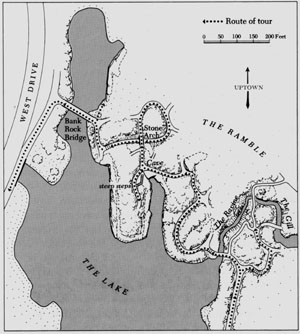
TOUR V: WOODLAND AND WATERSIDE
This tour presents several new rock types, a puzzle, a piece of geologic detective work and some notes on how the raw materials of the terrain -- scattered outcrops, springs and marshy hollows -- were blended with genius to create a unified work of art. The route is longer, rougher and damper than the previous tours so be sure to wear rubber-soled shoes -- or better, if you have them, hiking boots with lug soles.
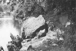
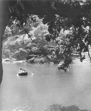
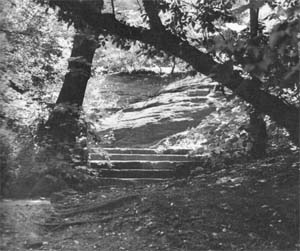
The tour starts at the Boat House at the extreme eastern tip of the lake, on the Fifth Avenue side of the park in line with 75th Street. Walk north along the bicycle rental enclosure, then west to the end of the fence where you are stopped by a massive outcrop. The exposed layers of the cliff display a dipping fold with the strata bent back on themselves at an acute angle. The layers are continuous on the outer margin, as can be seen at the nose of the fold just above ground level. The inner angle, however, was so sharp that the rock cracked under stress and pulled away from the less abruptly folded section to the right. The loss of contact is marked by a nearly vertical eroded cleft. Note that pegmatite, injected as molten rock, has flowed around and captured fragments of schist which were snapped off when the layer collapsed. Large quartz crystals form a pod in the center of the hollow and are conspicuous on the little shelf at the bottom of the cleft.
|
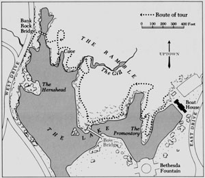
| Route of Tour V. |
This segregation of grains in an igneous intrusion is result of differences in the temperatures at which specific minerals crystallize out of molten rock, or magma in the technical term. Magma, insulated by the mountain mass enclosing it, took hundreds of thousands of years to cool. As the temperature slowly dropped, individual minerals reached their crystallization point in definite sequence. As grains formed, they adhered to the roof, walls or floor of a cavity.
When the majority of minerals had crystallized, quartz -- one of the last to form grains -- and the rarer elements were left in the depleted broth. Since most of the cavity had already been filled, quartz grains had to find space between grains deposited earlier, thus cementing them together. At the last, quartz grains formed in the center of the cavity. If the chemical content of the broth was favorable, gemstones could grow in spaces between the quartz crystals.
 |
| The Promontory. |
In actual fact, the process was seldom so orderly. Superior pressure from another quarter could crush the hollow, further compressing its contents and shooting them into crevices or weaker strata. Successive waves of scalding water, squeezed out of sedimentary rocks in a pressure zone, could invade the cavity, dissolving crystals already formed and supplying additional chemicals to form new compounds.
It is difficult to conceive of water coexisting with superheated rock, as one would expect the water to vaporize and dissipate. It is necessary to remember that the rocks we now see in the open were buried deep within a mountain chain. There was no way for the water to escape into the air so it spurted into any fissure that developed as the surrounding rock warped and buckled under compression.
Turn now to the northeast where three boulders stand close together. The topmost, perched on a flat outcrop, is diabase, a genuine erratic plucked from the Palisades and transported in glacial ice. Diabase is a fine-grained rock, dark gray where weathered but showing a distinct salt-and-pepper mottling on recently broken surfaces. As noted on the first tour, diabase is an intrusive igneous rock. If it had been expelled onto the surface by volcanic eruption, it would have cooled quickly into basalt which has microscopic grains. Diabase, because it cooled slowly within the earth, developed grains large enough to be seen readily with the naked eye. As a further means of identification, you will note that diabase, being an igneous rock, shows none of the layering of the sedimentary schist it rests on, and contains no mica.
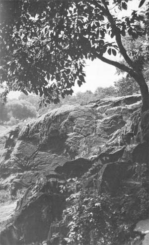 |
| Folded layering in the cliff face northwest of the Boat House. |
Walk around to the north side of the massive outcrop and climb up onto its surface. Deep glacial grooves mark the rise near the base of a backberry whose roots straddle the rock. Walk slowly down the slope to the west, pausing to study the patterns of folding which are especially well displayed on this broad tablelike surface. There are series of gentle waves like watered silk, some looping reverse curves and some angular zigzags like conventionalized lightning bolts.
When you reach the far end of the outcrop, turn east and walk back towards the fence on a ledge about ten feet above the water. If you center the corner of the Boat House porch railing between the first and second concrete blocks (counting from the west) you will be standing on a nine-inch granite dike, distinguished from its host rock by its fine grain and lack of layering. When you have located the granite, turn west again to see how it continues as a slightly raised band cutting across the intricately folded layers of schist. The line of granite is only slightly offset, indicating that it was injected after the host rock had undergone its most drastic deformation and begun to harden.
The molten granite, when first injected into a deep fracture, doubtless filled it tightly. As the magma cooled, a zone of weakness developed along its borders. The glacier, as it moved down the lee side of the outcrop, may have ripped off the top of the divided section along the line of fracture, leaving the ledge we stand on.
As you follow the granite dike to the west, you will find traces of a coarse-grained pegmatite border such as we saw on the last stop on Tour I. Large quartz crystals are especially conspicuous along the edges of the granite at the point where it rises well above the surface of the more readily eroded schist.
When you reach the far end of the outcrop where the granite dike dips beneath the water, turn back and try to fix its course in your mind so that you can locate it from a distance later in the tour.
 |
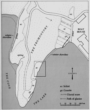
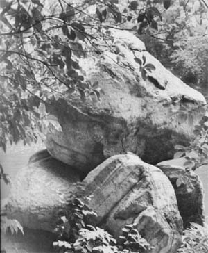
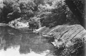
| Detail of the east shore of the Promontory. |
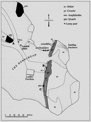
As you come off the outcrop, whose western tip is heavily lined with glacial scars, follow the row of upended rocks along the shoreline to the west. The first substantial rock you come to is a tilted slab, marked A on the detail map [at left], at the water's edge. Walk along the landward side of this slab for about fifteen feet until you approach a second rock (B). In the gully between the west end of A and the low extension of B are two small outcrops of a dark, fine-grained rock marked with narrow white lines.
 |
| The titled slab marked A on the detail map [at left]. The path that leads to the amphibolite is on its landward side. |
This is our first view of amphibolite which can be more conveniently studied where the path widens a short distance ahead.
The second slab, B, is an upthrust of rotting schist. If you look closely below its overhang, you will see many dull red to brown crystals, 1/8 to 1/4 inch in diameter. These are garnets in the rough. Tightly clustered garnets were used to pave the rather somber brooches and eardrops popular in Queen Victoria's day. Even when cut and polished, garnets have little luster and have been superseded in fashion by livelier stones, real or synthetic. Since these rough, flawed garnet crystals have no commercial value, leave them in place for other visitors to discover.
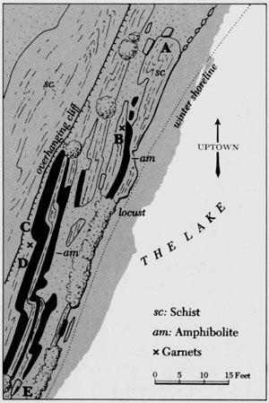
The layer of amphibolite, which continues along the base of slab B, is also rich in garnets. The footing is better at the next exposure so make your way between the landward side of B and a very prickly hawthorn thicket until you stand below a twelve foot cliff (C) on the north side of the rudimentary path.
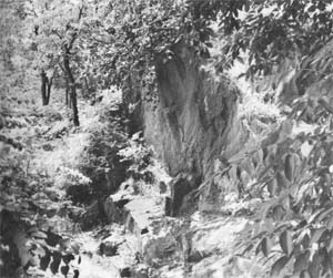 |
| The cliff marked C on the detail map. The shelf at its base is amphibolite. |
Below the nearly vertical cliff face is a sloping shelf of amphibolite, not a continuation of the first exposure but a separate layer. Amphibolite is a metamorphosed rock which records periods of intense eruptive activity in the chain of offshore volcanoes. It originated as basalt, a fine-grained blackish lava that cooled quickly on the surface. (If it had been injected underground, as in the case of the Palisades, it would have become diabase.) The action of waves ground the solidified lava into fine particles and distributed them over the floor of the inland sea. At the time the sediment was deposited, volcanic debris predominated over other sedimentary particles. Later, when the period of acute volcanism subsided, normal erosion from the steep flanks of the volcanoes resumed, resulting in a layer of shale. When the flow of lava again peaked and became dominant, the shale was covered with more powdered basalt, producing the alternating layers displayed in this area. These layers remained distinct throughout the metamorphic porcess which converted shale into schist and the basaltic sediments into amphibolite.
The white lines in amphibolite run parallel to the layering of the rock. As was the case with the quartz bands noted at the Balto stop on the first tour, it is not possible to determine whether these white stripes were formed by deposits of sand grains on the basaltic sediments or whether they result from igneous or aqueous injection.
The angular fracturing of amphibolite, as distinguished from the peeling and flaking of the schist face above it, is well demonstrated towards the east end of the shelf.
The amphibolite flows in a dipping fold around a jutting slab of schist (D). On the vertical face partly surrounded by amphibolite and in the basinlike hollow beneath, you will find another crop of garnets. The yellow to brown stains on the cliff face mark the former site of garnet crystals, either freed by erosion of the schist that once enclosed them or pried off by thoughtless collectors.
Several folded bands of amphibolite continue sporadically for three-quarters of the length of the cliff, then disappear below ground at the point where a block of schist (E) rests against the roots of a black locust. Thirty or forty feet farther west, scattered exposures of one of the bands of amphibolite reappear at the base of another glacier-steepened cliff, then dip below the surface about ten feet short of a clump of bamboo on the point.
A scant five feet south of the amphibolite's end, a band of granite appears. If you sight along its course, you will find that it lines up with the granite dike seen on the first outcrop and is probably a continuation of it. The coarsegrained pegmatite border is more pronounced on this section than on the part nearer the Boat House.
Walk over the crest of the rise and follow the unpaved path that leads north along the center of the promontory. About twenty feet beyond the beginning of the paved path, in a gully to the west, a small spring issues from under an artistically placed rock and runs down a pebbly course to the lake. It is better to postpone exploration if the ground is water-soaked or spongy with thaw. Even if you escape a fall, you will inevitably accelerate erosion as you slide down the unprotected slope.
When the soil is dry, you can walk down the slope on the north side of the spring. If you peer under the rock, you will see that the mouth of the spring is neatly bricked. This suggests that it may once have provided drinking water or that the outlet might have been capped in order to pipe the water elsewhere.
"Elsewhere" may be the mystery that waits just around the bend. In winter when the water level is low, you can walk north along the beach. When the beach is submerged in summer, you will find it easier to retrace your steps to the top of the rise than to press through a thicket of thorny locust saplings nearer the water. As you walk to the north end of a grassy opening, you will come out near the steep rocky cliff that forms the eastern wall of the cove.
 |
| The mysterious gutter on the cliff that forms the eastern wall of the cove. |
About halfway down the rock face is a gutter, chiseled with great exactitude for an inscrutable purpose. It is a matter of record that Olmsted despised naked rocks. He wrote to his head gardener, Ignaz Pilat, that nothing displeased and disappointed him more than the bare rocks on the north shore of the lake and around the cave, and he urged Pilat to blast holes if necessary to get vines started growing over them. By no standards, however, would this shallow, straight-line trench make a congenial or naturalistic container for plants. In any case, there are natural crevices in the outcrop which could have been enlarged with far less effort and greater effectiveness.
The proximity of gutter and spring suggest a connection. Was the water piped to flow along the channel, perhaps overflowing to encourage the growth of ferns and mosses on the cliff? Did it run on to create a tiny waterfall at the north end of the cove? A check with a Brunton compass showed that the gutter slopes uphill from the spring, thus disposing of an appealing hypothesis.
 |
| Looking west across the cove from the site of the spring. |
About midpoint on the outcrop, the gutter reverses its pitch and slants downward towards the north. In order to flow along both sides of the trough, the source of water must have been at the peak where the two sections meet. Seepage through the rocks is considerable, though apt to go unnoticed except in winter when it builds up into impressive mounds and columns of ice. However, no seepage is visible near the apex of the troughs. This high point may once have held the secret but, by ill luck, it has been carried away by a rock slide, taking all clues with it.
The problem appears impossible to solve from evidence remaining on the site. Anyone doing research on the park's history is urged to keep an eye out for an explanation. Meanwhile, any plausible guesses are welcome.
The trough reappears on the far side of the rock fall but it is hardly worth the effort of scrambling over the debris to trace its course, as it can be seen in its entirety from the other side of the cove.
Make your way uphill to the path, pass the railed section and take a hairpin turn to the left to follow the path around the head of the cove. At lamp post #7544, turn left and walk out onto the elongated outcrop that defines the line of the shore. Between this outcrop and the one just to its east is a simulated spring, in reality an overflow from the Gill to the north. The pipe that carried the water underground has been clogged or broken, creating a mud puddle across the path and, in winter, a dangerous ice slick. However, enough water still flows through the pipe to create a shallow pool on a slightly concave rock, to the great delight of birds that flock to bathe in the sliding film of water.
As you walk south on the outcrop, notice its fantastically intricate pattern of folds. This record of deformation holds the answer to a question frequently asked by children: "Are you looking for dinosaur bones?" (Grownups, on seeing someone intently interviewing a rock and writing the replies on a clipboard, walk hastily by on the far side of the path.) When you consider the intense heat and crushing that molded Central Park's rocks, you will realize that no fragile remnants of marine life, originally enclosed in sediments, could have survived.
 |
| Looking east across the cove. The dark line of the gutter is visible above the far shore. |
Towards the south end of the outcrop, look across the water between a willow and a leaning pine to see the mysterious gutter and renew your speculation on why anyone went to all that trouble.
When you return to the path near lamp post #7427, you will see a flat outcrop jutting into the pavement. The overall curly pattern of its folds looks like broadtail lamb. A drill hole in the center suggests that preparations were made to blast it. As long as our imaginations are flexed, we may picture Olmsted as he directed the transformation of the wasteland from horseback. It does no harm to fancy that he noticed the beauty of the rock and ordered it incorporated into the path instead of destroyed.
 |
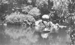
| Piled rocks at the mouth of the cove. The striped rock in the foreground is an erratic of ancient gneiss. |
As you walk south towards the point, you will see on the shore a pile of rocks topped by a mammoth hunk of pegmatite. This is rounded as if by a glacier but, being country rock, is not a certified erratic. However, the boldly striped rock below it to the southwest is an indisputable erratic. This is gneiss, a light-colored rock with medium to coarse grains and strongly defined black bands. It is a durable rock: while it contains a small amount of mica, the crystals are well distributed within the mass, not segregated in pervious bands as in schist. Gneiss is the most commonly exposed rock of the Bronx from whence it derives its local name of Fordham Gneiss. Our rock, however, was probably transported from the Ramapo Mountains as these lie in the direction from which the glacier ground its way to the New York City area.
Ramapo gneiss is a rock of such antiquity that it is difficult to comprehend in terms of human experience. In its more than a billion years of existence, it has undergone so many changes that its origin has been obscured. Some geologists believe that it is the primal rock formed as the Earth's crust cooled and hardened. Others consider it to be composed of sediments from erosion of this first rock. However it came into being, we know that gneiss is the foundation for the marine sediments that later were metamorphosed into marble and schist. Touch it with awe. It is a link with the birth of our planet.
This rock pile, like those on the Sheep Meadow, was intended to be festooned with vines and buttressed with shrubs, a landscaping device to break the flatness of the shoreline. Old illustrations of the park show how effective these pillars of foliage were and how they created a feeling of seclusion by screening leisurely strollers on the shaded paths from more athletic adventurers in boats on the lake.
Farther west, between the point and Bow Bridge, another support for vines stands ludicrously with its spindly props exposed. Like the huge boulder by the carousel, this one looks dangerously insecure on its seemingly inadequate footing. Frequently you will find a stick thrust through the chinks in the base in an effort to unseat the rock, but it must be solidly mounted, as the ingenuity of generations of city hoodlums hasn't brought it down.
Bow Bridge, ahead on the left, now one of Central Park's most celebrated treasures, was something of an afterthought. The original plan shows no bridge across the lake. The only way to reach the Ramble and Vista Rock from the south was to go the long way round by following the lake shore.
Vista Rock, the high point in the northwest corner of the Ramble, was the controlling factor in the design of much of the lower part of the park. The Mall was angled so that the view along its tree-walled promenade was directed to Vista Rock, at first topped by a wooden observation tower and later by the battlements and turret of the Belvedere. The effectiveness of this remote focal point, with its apparent distance increased by an expansive sheet of water, was so highly regarded that a stretch of the Ramble was kept cleared of trees so that nothing could impede the view.
Visitors were of course attracted to this artfully devised enticement but some were unequal to the long, uphill walk needed to reach it. To provide a shorter route, Calvert Vaux and his artist-assistant, Jacob Wrey Mould, designed Bow Bridge and set it around a bend in the lake shore where it wouldn't distract from the supremely important line of sight to Vista Rock.
Bow Bridge, like all of Central Park's structures, has suffered from lack of maintenance. Through failure to keep the joints of the bridge tightly caulked, water entered the hollow cast iron members. By 1972, the bridge was so near total collapse that visitors in rowboats were endangered by pieces of ironwork falling into the water.
Bow Bridge was restored through matching gifts by Mrs. Henry L. Moses and Mrs. DeWitt Wallace, members of the Friends of Central Park. It was dedicated in 1974, the 150th anniversary of Vaux's birth. The restored bridge stands as a lasting tribute to the generosity of the donors and to the creative genius that earned Central Park its status of one of America's foremost works of art.
About 25 feet from the northwest corner of Bow Bridge, you will see one of the few vine-draped rocks surviving in Central Park. Even when the wisteria is leafless, its softening effect is evident, as can be seen by comparison with the sterile stretch across the path. The artifically supported vine serves as a barrier to indicate a change of direction to those who approach from the lakeside path we have just followed. This device, so simple yet so effective, should be used wherever broken rocky surfaces and heaps of jagged rocks offend the eye. Olmsted strove to give a "luxuriant jungled variety and density and intricate abundance to the planting of the lake border and the Ramble." His planting instructions, ignored for a century, await the appointment of a qualified landscape architect to direct the renascence of Olmsted's verdant countryside.
There is a fairly long walk to the north along the lake shore before the next top. If you are tired, there are benches just ahead. While you are resting, you may like to know something of the condition of the area as Olmsted and Vaux found it.
 |
| Looking northwest across the Ladies' Pond with Balcony Bridge and the roof line of the American Museum in the background. |
Central Park Lake follows the course of a small brook, the south branch of Saw Kill which derives its name from a sawmill built in 1664 by Jan Van Bommel at Avenue A. The stream gathered into a marshy pond in the hollow where the American Museum of Natural History now stands, then entered the park site between 76th and 77th Streets. It curved south around the Hernsbead, then ran more or less directly across the park through a wide marshy valley now occupied by the lake, the Terrace and part of the Mall, and then left the tract between 74th and 75th Streets on the Fifth Avenue side.
As Olmsted wrote in his description of the prizewinning Greensward plan, "Mere rivulets are uninteresting, and we have preferred to collect the ornamental water in large sheets, and to carry off through underground drains the water that at present runs through the park in shallow brooks." In forming the outlines of the lake, Olmsted took full advantage of the steep rocky bluffs on the north side, weaving around them little coves and bays that invite exploration, and creating the illusion of inlets to other lakes just around the bend. The superlative artistry of the design exemplifies Alexander Pope's mid-Eighteenth Century rules for landscaping: "Contrasts, the management of Surprises and the concealment of Bounds."
The south bank of the lake was filled with stone blasted from other parts of the park and covered with four feet of soil. The shallow root run may explain why many trees fail to thrive on the Mall. The bed for the lake was widened and deepened, and the water level raised by an earth dam which carries the present Boat House and a stretch of East Drive. The overflow from the lake once provided a waterfall in a romantic grotto above a rock-edged pool, now replaced by the doleful statue of Hans Christian Andersen. From there, it was piped into Conservatory Water, the formal pool that approximates the original level of the terrain.
Where it entered the park on the west side, Saw Kill once filled a shallow ornamental pool shaped like a butterfly with one wing on either side of the massive stone bridge at 77th Street. When the pond was filled in 1880 as a result of a panic over malaria, the little brook was confined to an underground pipe. However, Saw Kill proved irrepressible. Guards at the American Museum say it wells up in the men's locker room after a heavy rain, and the sound of running water can usually be heard in the lower level of the subway. The brook has succeeded in bubbling up into the sunlight to form a little stream running to the lake, as you can see if you look north from the bridge. Tiny as it is, this artery represents a triumph of nature over repressive urbanization, and should be welcomed with an appropriate setting.
 |
| Detail of route through the Ramble. |
Central Park Lake illustrates the way a genius at landscape design can turn a marshy waste into a feature of surpassing beauty. The next stops show how the same freewheeling imagination added grandeur, drama and high adventure to existing rock formations in the rugged heart of the Ramble.
Walk north from Bow Bridge, keeping to the waterside. If you wish to make a detour to look down on a manmade cataract, turn sharp right at lamp post #7525, then left at the top of the stone steps, a second left at the fork, and continue north past #7529A until you see the bridge railing ahead. The dam, faced with massive boulders, impounds the waters of the Gill, the intimate series of little brooks and pools that gives the Ramble much of its lyric quality. In case you have brought a sandwich, the natural rock slopes to the east provide one of the most charming and secluded picnic spots in the park.
When you return to the lower path, walk north, turn left around the bend, and then right on a narrow path at lamp post #7529. Here the Gill empties into a stretch of rapids, a replica for city dwellers of a white-water stream in the Catskills or Poconos. Reversed from left to right, the scene bears an uncanny resemblance to Asher Durand's painting (to be seen in the New York Public Library's main building) in which William Cullen Bryant and Thomas Cole, founder of the Hudson River School of landscape painting, stand on a projecting rock shelf to admire a cataract and rushing stream in the ravine below.
Olmsted based his reproduction of mountain scenery on the existing outcrop to the west, then added drama by building rocky banks and the rugged cliff from which the water issues. By now you don't need to be told that the banks, and especially the heaped-up rocks, are meant to be smothered in shrubs and vines, not revealed in all their artifice.
Where water should foam down the rocks, there is a miserly trickle. The Gill with its earth banks is too fragile to sustain a greater volume of water, but it would be easy to pipe in an additional supply (through a well-hidden pipe, of course) so that water might leap down the face of the cliff instead of dribbling from a culvert.
 |
| Stone steps leading to the dam. |
The scene is marred by a crude, much-cemented dam, an example of the damaging alterations to the original plan that stem from lack of informed supervision. Throughout his writings, Olmsted emphasized the humanitarian purpose of the park's design: to supply "a considerable variety of natural landscape scenery ... for the hundreds of thousands of tired workers who have no opportunity to spend their summers in the country." To this end, he determined to interfere with the site's "picturesque, rocky scenery as little as possible," and added in his directions to gardeners, "The less anything that is seen appears to have been dressed up by human hands, the better." If the administrators of Olmsted's park had read his instructions and ordered all foremen to see that they were enforced, no workman would have been permitted to turn Olmsted's mountain torrent into a duck pond.
Unlike most abuses of the landscape -- the stripping of soil-holding vegetation from hillsides, the removal of lower branches that turns trees into floor mops, the merciless mutilation of ground-sweeping shrubs -- this blunder is easily reversible. Give it a few whacks with a sledge hammer, chip off any remaining traces of cement, and you have made a significant start towards restoring the atmosphere of wildness. Meanwhile the water, as if rejecting constraint in favor of Olmsted's free treatment, dodges under a boulder and regains its intended channel.
When you return to the path, cross the bridge, go up the steps and turn left, again keeping to the waterside. After you pass a large rock jutting into the water, watch for lamp post #7533. Just beyond it, walk out onto an outcrop on the left and circle below a balanced rock. Look for a huge visored rock slightly to the left of the far end of the cove. Below its overhang was a rock shelf that once served as a boat landing; to its left is the former entrance to a cave, once one of the marvels of Central Park. As we shall see shortly at closer range, the cave was in fact a narrow cleft, a natural fissure in the rock which was roofed over to form a tunnel.
The fetid mudhole at your feet, silted with erosion from stripped banks and clogged with refuse and fallen trees, was once an idyllic tree-bowered approach to the cave. Adventurous visitors, after mooring their boat, could grope their way between rocky walls and come out to daylight near the base of a stone bridge on the landward side.
Before leaving the spot, notice the curious overlay of pegmatite that fits over the north end of the outcrop as snugly as a watch cap.
Return to the path and continue up the hill, taking a sharp left at lamp post #7635. Circle around the head of the cove, following the iron railing, to the steps on your right. If you walk about five yards farther west and look over the fence, you will see the flat rocks that roof the cave. Beyond them, across a little hollow, you can see a flight of steep steps hewn from solid rock. Continue following the railing to #7623A, from which point you can see the overhang that looms over the boat landing. If you walk about seven yards farther and turn to look back, you can see the walls of the cave, a cleft between the main mass of the outcrop to the left and the visored rock which seems to have tilted to the east.
The mouth of the cave is sealed with stone and cement and must remain so until Central Park once again has its own force of guards.
The steps, which look even more precipitous when you look down on them from directly above, are both shallow and slippery. They were once furnished with a handrail but only a trace of its support is visible at the bottom. If you must go down to inspect the cave, there is little to choose between these hazardous steps and the equally slippery, thorn-beset slope to the south.
As you look across the cove, you will see that many of the rocks that form its bank have slipped downward, almost closing the inlet. These rocks were put in place by hand- and horse-powered block and tackle. It is unlikely that they will be replaced today even with the availability of mechanized equipment. Even so, the cove could be cleaned and dredged and its slopes replanted to restore the setting of the cave if not access to its high adventure.
While directions for locating the cave were being worked out, a hippie couple -- beard, long hair and frayed dungarees flying -- were pushing a baby carriage at incredible speed around the steep, winding paths in the area. As they swooped past, flushed with exertion and delight, the girl exclaimed, "The only thing real nice about New York is Central Park." Olmsted and Vaux, wounded to the heart by the outrages inflicted on their work of art, might be consoled to know that, however tragically mutilated, the park still asserts its intended spell.
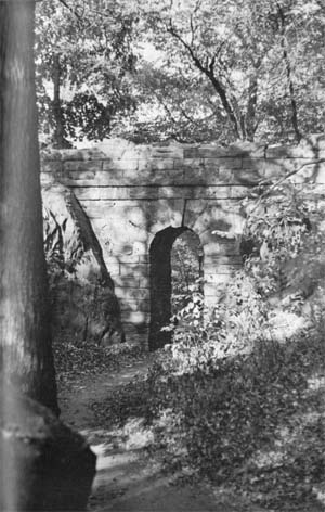 |
| The high-arched stone bridge spanning the ravine. |
Walk back to the steps, climb them and walk out onto the bridge. The boulders that form the parapet are cut to interlock and, like the bridge itself, are laid without mortar. This is a display of consummate craftsmanship, a silent rebuke to the present decline of standards which permits replacement of missing boulders with crude patches of broken stone slobbered with cement.
Cross the bridge, make a full circle to the right and go down the steps that lead to the high span. At close range, you can wonder at what may be nearly a lost art: the shaping of stones so precisely that friction, not mortar, keeps the arch intact. The landward entrance to the cave, now obliterated by a bank of earth, was located at the south end of the outcrop to the left.
This bridge, whose apparent height is increased by the narrowness of its span, is a telling example of how Olmsted added drama to an existing rock formation. If you step back and forth under the bridge, you will see that the whole concept hinges on the long, steep outcrop to the south. This wall was duplicated on the north side of the path by laying up huge slabs of rock. As early pictures show, the seams were so well hidden by dense foliage that the natural and man-made walls were indistinguishable.
The ravine thus created provided an ideal site for a lofty span. The top and sides of the bridge were so thickly hung with vines that the structure was minimized and the narrow archway apeared to be a natural gap in the rocks. This elaboration on an existing outcrop to make a scene of great dramatic impact is one of Olmsted's most successful mergers of nature and art.
 |
| The outcrop northeast of Bank Rock Bridge. The ridges of the step formation are visible below the slanting tree trunk. |
After you have paid due homage to Olmsted, continue walking west and turn right at the foot of the steps. Instead of crossing Bank Rock Bridge, stop at its east end. The outcrop on the lake shore, below and to the north, is the setting of a geologic detective story. You will be able to examine the evidence at close range if you slide down the steep slope and walk out on the narrow beach at the base of the outcrop. However, if this approach is too muddy, you can get almost as good a look from the top of the outcrop which you can reach from the path to the east.
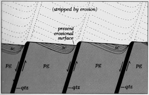 |
| Schematic diagram of Bank Rock outcrop. |
The outcrop is predominantly pegmatite, recognized by the coral-pink grains which are especially well displayed near the top of the bank. This is the first large mass of pegmatite we have seen in situ, not merely as an isolated boulder. Up to now, intrusions of igneous rock have been fairly narrow ribbons, too slight to have any marked effect on the host rock. Here, however, a flood of superheated, gas-charged magma was forced upward into fractures and ended by engulfing its host.
To a novice's eye, the surviving triangles of schist seem too regularly spaced to be natural. To add to the puzzle, the lines of contact on the north side are as sharp as if they had been applied with a putty knife, while the juncture to the south seems to blur as if the schist had melted and run into the pegmatite. Since the magma subjected both walls of the fracture to the same devastating heat, it would seem that the reaction should be uniform on both sides.
According to the geologist's reconstruction, the triangles of schist are all that survive of a massive unit that once extended westward. While buried deep within the Earth, the schist was overwhelmed by a great burst of molten rock. When the schist and its thick pegmatite shell had cooled enough to lose plasticity, the combined mass was subjected to overwhelming pressure from the direction of the bridge and fractured under stress. Because the force was exerted at an angle to the present face, each section was pushed to the northeast along the line of fracture, forming a succession of setbacks. Veins of quartz, conspicuous by large grains near the top of the outcrop, sealed the fractures.
Millions of years later, when the overlying mountains had been reduced to plains and the schist was exposed to weathering, it eroded except for the slivers that remain embedded like shallow inlays in the pegmatite. The inlays are deepest at the north where they are protected by the angle of the setback, then grow thinner as they slant off towards the south, and finally taper to a mere veil of rock through which the grains of pegmatite are visible.
If you climb around the top of the outcrop and look down from its top, the step formation is more plainly evident. The flgure below, which represents a cutaway section of the outcrop as seen from above, will help you to visualize the structure: a series of offset pegmatite blocks cemented together with veins of quartz and retaining the ghostly imprint of a vanished mass of schist.
Return to Bank Rock Bridge and cross it, continue to the left at the top of the hill, cross Balcony Bridge and take the first path to the left around lamp post #7507. The path to the Hernshead divides at lamp post #7509 to flow around a little wooded island with a tall, spreading shrub at its northern tip. This is a native witchhazel,Hamamelis virginiana, whose normal flowering season in October and November is zany enough. This delightful eccentric was in full bloom on December 19, 1972, when the temperature was in the low 20's. At the usual time of bloom, the ribbony, pale yellow flowers are apt to be overlooked among the deeper yellow autumn folliage. The flowers of this specimen, strung along bare twigs like slightly disheveled dandelions, created a warm glow in the gray landscape.
On January 13, the witchhazel, still bright with flowers, had been reduced to one spindly stem. A picturesque rock-clasping black cherry had been cut down, along with many hawthorns. Hackberries and other wild-growing trees showed glaring wounds where their lower branches had been sawed off. Worst of all, the shrubs on the island and south to the Hernshead had been whacked back to two-foot stubs.
 |
| The north face of the Hernshead. The slanting rock in the near right hand corner is the edge of the granite layer. |
The shoreline that curves north from the Hernshead was, at this time, the only surviving lake border that accorded with Olmsted's ideal of luxuriant growth. Shrubs and low-branched trees formed an impenetrable thicket with branches that stretched out over the water to reach the light. The shoreline, softened and protected by a bower of foliage, presented a telling contrast to adjacent banks of eroded yellow clay. In an effort to save the remaining planting, an emergency call went to the Arsenal and brought an order to the uniformed vandal to stop his destructive work immediately. The man promised to use great care and to remove nothing but dead wood.
Four days later, the entire area had been stripped as far north as Balcony Bridge and west to the drive. Cars, formerly screened from view, now seemed to run right through the once-secluded haven. Gaps between the mutilated shrubs invited trampling and erosion and opened a view to the lake shore, now an unprotected, garbage-strewn mud flat.
The fact that an employee had wantonly destroyed plant material, defied an order to stop and lied about his intended action was incontrovertible proof of a breakdown of horticultural standards and discipline in the Park Department. The commissioner, Richard Clurman, was outraged by the senseless devastation. Soon afterwards, he engaged an executive horticultural director and a professionally qualified horticulturist to set up new rules of procedure in caring for the park and to train a corps of gardeners and tree men in approved techniques.
Samuel Parsons, Jr., a superlative plantsman, was Calvert Vaux's staunchest ally in defending Central Park against the outrages inflicted on it by Boss Tweed and his Tammany Hall cronies. Parsons' assessment of park administration was based on bitter experience: "All the troubles of the New York Park Department have arisen from failure to understand the value of expert advice."
The Park Department today has added a refinement to Parson's observation. Instead of merely ignoring expert advice, they eliminate the advisors. By the end of 1974, not one of the gifted consultants appointed by Mr. Clurman remained in office.
Without the guidance of informed leaders, Park Department officials have renewed their attacks on the landscape, mercilessly limbing up trees, slashing away understory plants and mutilating shrubbery. Boss Tweed's dishonored ghost is back in command of Central Park.
It is evident that the historic natural landscape parks cannot survive under present standards of management. Their administration must be put beyond the reach of political interference and patronage and released from the dominance of Civil Service and an antiquated union. The solution may well be a counterpart of the National Trust in Britain: a group of highly qualified specialists in history, horticulture and landscape art who would bring wisdom and integrity to the preservation of the city's most vital landmarks.
The imperative need for sensitive, intelligent horticultural direction is displayed throughout the Hernshead. The area still bears the scars of its 1973 ravaging. Butchered shrubs show decaying stumps at their base while weeds such as ailanthus have seeded between their thinned shoots. The little island, the oval plot enclosed by paths, has been replanted in a rigidly artificial pattern. Shrubs of one kind and size, massed as thickly as pansies, have been set in a straight line against a different all-one-kind planting. In nature, the shrubs would intermingle and would be scattered on both sides of the path instead of being confined in a tight knot in the center. Even the freest planting, however, wouldn't serve to make the ill-chosen Chinese bayberry look at home in a native woodland planting.
 |
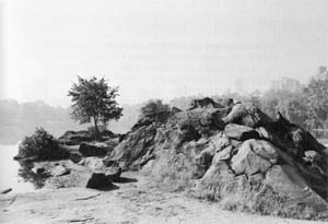
| The Hernshead. |
At the south end of the path-encircled island is a thick outcrop of amphibolite. Compared to the specimens seen near the Boat House, this is coarser grained and, because of the infrequency of white layers, appears to be darker in color. If you follow the direction of layering to the northeast, you will find the amphibolite reappearing at the water's edge, half hidden by a drooping mulberry. This mass is fully thirty feet thick, recording an exceptionally prolonged period of volcanic activity on islands offshore. The outcrop can be seen from the Hernshead so it is not necessary to tramp through the bushes and perhaps hinder regrowth.
The Ladies Pavilion, standing just west of Hernshead Rock, is a delectable Victorian fantasy in cast iron. It was designed in 1871 by Jacob Wrey Mould, co-designer with Calvert Vaux of many park bridges and creator of the lavish sculptural details of the Terrace. Originally titled "Ornbra for Passengers in Waiting," the structure stood on 59th Street near Columbus Circle where it served to shelter people waiting for horsecars. Displaced by the Maine Monument, the shelter was moved into the park in an almost unique instance of historical preservation. As the building was fitted with benches along its inner sides, it provided a place for women to sit while putting on their skates. The new name of Ladies Pavilion derives from its proximity to the Ladies Pond, the arm of the lake north of the Hernshead which was reserved for women and children during the ice skating season.
The Ladies Pavilion was allowed to fall into ruin for lack of care. As conspicuous neglect of maintenance inevitably invites vandalism, the building was pulled down and virtually destroyed in 1971. Plans for restoring the Ladies Pavilion were paid for by the Friends of Central Park. The work was directed by Joseph Bresnan, Monuments Officer, who also supervised the rebuilding of Bow Bridge.
The Hernshead outcrop is complex and full of contradictory evidence. If the rock seems lower than when you last saw it, it is because repeated visits for examination, with hours spent in scrutiny, arguments, insights and retractions, have worn it down. The process of unscrambling the probable origin of the rock mass will be a revelation to anyone who has assumed that geology is a cut and dried subject and that all the answers can be found by looking in the back of the book.
As you walk out onto the rocky platform at the northern tip of the promontory, look along the shoreline to the northwest. The large outcrop of amphibolite, seen earlier from the path above it, stands out boldly under its canopy of mulberry branches. You can refresh your memory of the appearance of amphibolite by looking to the three boulders that form an arc along the beach just west of the mass you stand on. The dark color, fine grain and clearly marked cream-white lines are characteristic of this lava-derived rock.
The flat platform at your feet displays two kinds of rock: to the east, the familiar schist with its folded layers; to the west, a band of fine-grained granite which, at its northern tip, is a good six feet thick. This granite is gray in color, not tan like the specimens seen previously, and shows no pegmatite borders where it meets the schist. If you follow the line of juncture towards the northern end of the outcrop, you should be able to locate several fragments of schist enclosed in the granite. The supposition is that such captured bodies of alien rock, called xenoliths, were broken from the host rock by the force of invading magma and imprisoned as the molten material solidified. The presence of xenoliths is usually taken as proof that the rock containing them is of igneous origin, not formed by the gentle deposition of sediments.
The flat rock surface of the northeastern tip of the outcrop is crisscrossed by hairline fractures. The sealant in this case is chiefly microcline, to judge by its pink color. This cementing material appears less durable than the quartz filling we have seen before. Many of the cracks have reopened -- fairly recently, if their sharp, unweathered edges are evidence. The wedging action of frost will likely widen and deepen the fractures until after many centuries the outer edge of the outcrop will split and fall into the water.
Now turn south to examine the face of the cliff where weathering has emphasized the wavelike folds of the schist and of the granite which conforms to each rise and hollow. If you can carry in mind the way granite fills the trough between two hills of schist, it will help you to understand an obscure feature later in the tour.
The cliff is a cross section of the rock mass. The fracture, which cuts at an approximate right angle to the plane of the layers, displays a complicated pattern of folds. By contrast, the west side of the outcrop is a longitudinal section. As we shall see presently, the schist here is split along its lengthwise grain and its surface is therefore relatively smooth and free of folds.
On a reduced scale, the structure of the Hernshead bears a resemblance to that of the Palisades though the component rocks are not the same. Originally both consisted of layers of country rock separated by a slice of different material. In both cases, the top layer eroded, leaving the filling exposed like an open-faced sandwich.
Walk around towards the footpath at the west side of the outcrop where two slabs of schist (B) are propped against the granite. These are all that remain of the top layer of schist. The upper surface of the granite lies parallel to the layering of the schist. If the granite is of igneous origin, it is a sill, not a dike.
At the south end of the second slab, you can see traces of schist inset in the granite face. If you look between the slabs and the granite, you will see more of these ghosts: thin slices of schist that clung to the granite and remained embedded in its face when the main slabs split away. These traces of schist are similar to those we saw at the Bank Rock stop though here the ghosts are not so regularly spaced. If you come shortly after a rain, you can plainly see the dark stains of water retained in the mica-bearing layers. By the action of frost, these ghosts will in time flake off as the larger slabs have done.
So far everything we have seen fits neatly into the theories of rock formation demonstrated so far in the park. The anomalies crop up about thirty feet south of the paved path. As you follow the slope of the outcrop, look for a pod of large quartz crystals (C) about two feet above ground. At the extreme northern end of the quartz, about 3 1/2 feet from the base of the outcrop, is a little shelf. On its top is a narrow layer of quartz, sharply folded in a zigzag pattern, with one edge exposed on the vertical face below.
At the tip of the quartz pointer and continuing across the shelf as it slopes down to the north are some traces of layering. Such layering is characteristic of sedimentary rock but not of granite which, if it entered a fracture as superheated mush, should be as homogeneous as a cake of soap.
For an explanation of the presence of layering in granite, we must turn to a recent hypothesis, once hotly contested but now gaining general acceptance. According to this supposition, granite can be formed in place, not solely as an igneous intrusion. It is proposed that existing rock can be transformed into granite by a combination of heat, pressure and infiltration of superheated water and chemically active gases released during metamorphism.
The process, called granitization, has a corollary: as the temperature of the existing rock mass approaches its melting point, some susceptible layers (perhaps those containing a large proportion of quick-melting quartz) might fuse and recrystallize while more resistant layers retained their schistose nature.
Walk back towards the slabs to see how the hypothesis holds for this outcrop. Notice that there is no sharp line of demarcation between granite and schist as we have seen in unquestioned igneous intrusions. Instead, the traces of schist are interleaved with granite to a considerable depth. More significantly, the inclusions of schist lie parallel to the prevailing layers in the outcrop. Fragments that had been ripped off and whirled around in a tempestuous flood of magma would be unlikely to come to rest in their original alignment. Therefore, the consistent orientation of the alternating layers of schist and granite suggests that they resulted from selective granitization and not from an intrusion of molten material.
Return to the pod of large quartz crystals (C). Above them is a smooth slab of schist with unusually large grains and shiny plates of mica. About eight feet from the ground, a tapering band of granite is set in a dipping fold of schist. Can you recall how granite filled hollows in the schist on the cliff at the north end of the outcrop? If so, you can visualize how such a roll of granite, when leveled by erosion, would persist as a shallow inlay in the trough. At the south end, where the nose of the fold nears the surface, the granite overlay is so thin that the grain pattern of schist is visible through it.
You can climb the outcrop at this point or, if the ground isn't too muddy, circle to the east side where the approach is more gradual. As you walk north towards the highest point, you will see that the granite is interspersed with scattered layers of schist. These lie parallel to the layering in the main body of schist. In several places, especially close to the line of contact, the granite exhibits streaks of dark grains which may be relics of sedimentary layering.
However, when you stand on the brow of the cliff and look down on the platform, remember the xenoliths which are usually considered proof of an igneous intrusion. The problem of the Hernshead granite is too knotty to solve in the field. It calls for laboratory tests -- for instance, dissolving the granite in acid to search for resistant wave-rounded grains, and microscopic examination of thin sections by means of polarized light. Meanwhile, what remains for us are some informed speculations and an appreciation of the delicious perversity of nature which refuses to be confined by any rigid system of rules.
 |
| Looking north along the east side of the Hernshead. |
From the top of Hernshead Rock, the serene expanse of water seems limitless. Although the scene appears to be natural, it is in fact a triumph of design, following Pope's precept on "the concealment of Bounds." When you stop to analyze the picture, you realize how skillfully the actual boundaries of the lake have been disguised by the use of bays and inlets which suggest another body of water just around the bend.
The shoreline to the northwest, until recently ornamented with lush foliage, shelters a stream that curves around the promontory and out of sight. Bank Rock Bridge provides a focal point and reveals an inviting and indeterminate glimpse of water on the far side. Across the lake, a small rocky cove, half hidden, breaks the sweep of the shoreline. A wooded island once stood off the southwestern tip of land, lending an air of mystery as it veiled the eastern arm of the lake. The island is now virtually obliterated by trampling. Its rebuilding and planting -- with material thorny enough to repel boarders -- is an appealing project for an informed donor. At the southern terminus of the lake, Olmsted set a grove of bald cypresses. These have vanished; in their place, thinned shrubbery reveals automobile traffic, thus destroying the artfully contrived illusion that the lake stretches on into infinity.
While changes detract from the landscape picture, these are superficial and reversible. The vital framework of the design remains intact, awaiting the hand of a sensitive plantsman.
Even with a flawed view, the great rock that crowns the Hernshead holds a matchless air of spaciousness, a sense of splendid isolation not to be found in city streets or on the stoops of tenements. Lovers and dreamers respond to its spell, drawn to the cliff overlooking the water as if it were the prow of a ship or a headland jutting into the sea. Perhaps nowhere else in the park is the designers' purpose better realized: to provide for people of the crowded city "a sense of enlarged freedom."
Washington Irving:
It is a mortifying circumstance, which greatly perplexes many a painstaking philosopher, that nature often refuses to second his most profound and elaborate efforts; so that after inventing one of the most ingenious and natural theories imaginable, she will have the perverseness to act directly in the teeth of his system, and flatly contradict his most favorite positions.
 |  |  | ||
| Previous page | Top of page | Next page |